Automatic digital rock drawing using a "ladder style" representation
příspěvek v recenzovaném konferenčním sborníku
en
postprint

Autor
Lysák, Jakub


Datum vydání
2024Publikováno v
European Cartographic Conference – EuroCarto 2024Nakladatel / Místo vydání
International Cartographic Association (Vídeň)Ročník / Číslo vydání
2024 (7)ISBN / ISSN
ISBN: 0-000-00000-0Informace o financování
MSM//SVV260694
UK/GAUK/GAUK87624
UK/COOP/COOP
Metadata
Zobrazit celý záznamKolekce
Tato publikace má vydavatelskou verzi s DOI 10.5194/ica-abs-7-81-2024
Abstrakt
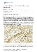
Topographic maps are a source of very detailed information about the terrain and serve as a basis for fieldwork in many sectors of human activity. Cartographic processing of areas with rock formations is often a rather complicated task due to their specific characteristics, especially steepness and ruggedness. One of possible ways to depict rocks in the map very well, is by hachures. However, the manual creation of hachures is very demanding, both technically and in terms of time. At the same time, the automatic creation of hachures for the representation of rock formations has not yet been satisfactorily solved completely, although partial successes have already been achieved recently.This paper deals with automation of drawing rock hachures in the "ladder style", an approach frequently used in maps of Central and Eastern European countries. The presented approach is focused on the automated creation of cartographic representations of rocks primarily for the purposes of the Czech state map series, while with certain modifications and necessary data it could be applied elsewhere.The proposed procedure is based on 3 types of input data: polygons representing the ground plan of the rock areas, a digital terrain model (DTM) in the vicinity of the rock formations and selected terrain skeleton lines in the areas of the rock formations or their surroundings, derived from generalised DTM. The whole procedure involves several sub-steps.The processing is carried out sequentially along the individual polygons of the rock formations in a following way: - generalization of a DTM, as it is usually too detailed for the purpose of hachuring. To generalize the DTM, the Line Integral Convolution (LIC) method is used, which preserves significant edges during the generalization process.- vertical hachures generation based on the generalized DTM and, eventually, the terrain edges. Vertical hachures follow the steepest gradient of generalized DTM. Starting at highest unprocessed pixel of DTM in shaded part, or at lowest unprocessed pixel of illuminated part, a hachure is drawn downhill or uphill, until several conditions are met. Pixels of DTM along a successfully created hachure are marked as processed. By repeating, the area of the whole polygon is gradually filled.- horizontal hachures generation. These are made up of contour segments of suitable elevation created from the generalized DTM. The contours segments are used only locally to create "rungs of the ladder".- emphasizing ridgelines and upper part of rock, using affine transformation of a predefined pattern, aligned with vertical hachures.- shading of the vertical and horizontal hachures and representations near the upper edge of the polygon is performed, using an illumination model derived from generalized DTM.The aim of this paper is to present experimental results of the outlined procedure and its known limits. Although the "ladder-style" portrayal of rocks is not so sophisticated as the "Swiss-style", it is traditionally used in Czech topographic maps and state map series. The presented algorithm could significantly contribute to the creation of topographic maps regarding rock formations, or to reduce the amount of manual work required in their creation.
Klíčová slova
rock hachures, digital cartography, topographic map
Trvalý odkaz
https://hdl.handle.net/20.500.14178/3043Licence
Licence pro užití plného textu výsledku: Creative Commons Uveďte původ 4.0 International